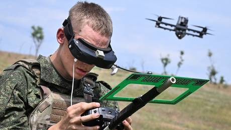
Ground-based radio frequency detection systems suffer from a structural, physics-based constraint: the line-of-sight horizon limitations dictated by terrain masking and Earth curvature. Moving the sensor to an airborne platform solves the geometric limitation but introduces severe engineering trade-offs regarding payload weight, power consumption, and aerodynamic drag. The integration of Sky Spy’s autonomous portable signals intelligence system, the SkyAgent 001, into Evolve Dynamics’ Sky Mantis 2 rotary-wing uncrewed aerial system isolates these specific trade-offs.
By evaluating this architecture under an electromagnetic warfare "capture the flag" exercise managed by France's Cyber Defence Command, the system demonstrates how tactical intelligence extraction scales horizontally across NATO operating concepts. Understanding this transition requires examining the physics of airborne radio frequency sensing, the operational feedback loop derived from Ukrainian combat theaters, and the structural friction inherent in updating conventional electronic support measures.
The Triad of Airborne Radio Frequency Spectrum Awareness
Passive electronic sensing from an uncrewed platform relies on three distinct operations to convert raw electromagnetic emissions into actionable targeting coordinates. Ground-based systems require extensive mast heights to achieve a clean line-of-sight against low-altitude transmitters or tactical radios operating in defilade. Elevating the receiver via a rotary-wing platform modifies the operational range equation by mitigating local clutter, but forces the system to calculate geolocation despite platform vibrations and engine electromagnetic interference.
+------------------------------------------------------------+
|                  AIRBORNE SIGINT INGESTION                 |
+------------------------------------------------------------+
                              |
                              v
+------------------------------------------------------------+
| 1. SIGNAL CAPTURE & DISCRIMINATION                         |
|    - Instantaneous Bandwidth Scanning                      |
|    - Dynamic Threshold Tuning vs. Ambient Noise            |
+------------------------------------------------------------+
                              |
                              v
+------------------------------------------------------------+
| 2. ALGORITHMIC CLASSIFICATION                              |
|    - Mathematical Signature Analysis                       |
|    - Pulse-Doppler / Hopping Sequence Extraction           |
+------------------------------------------------------------+
                              |
                              v
+------------------------------------------------------------+
| 3. GEOLOCATION CALCULATION                                 |
|    - TDOA / FOA Intersections                              |
|    - Conversion to Military Grid Reference System (MGRS)   |
+------------------------------------------------------------+
1. Signal Capture and Discrimination
The sensor must scan across wide instantaneous bandwidths to intercept high-priority emitters. These emitters include frequency-hopping tactical radios, command links for first-person-view strike assets, and localized electronic attack jammers. The system employs dynamic threshold tuning to separate intentional military emissions from background environmental noise and civilian communications infrastructure.
2. Algorithmic Classification
Once an emission crosses the detection threshold, the onboard software applies mathematical sorting routines to isolate the signature. The software parses the waveform’s modulation format, pulse-repetition frequency, and frequency-hopping sequence. This taxonomy categorizes the emitter according to threat priority, identifying whether the signal originates from a telemetry link, a ground control station, or an active electronic warfare asset.
3. Geolocation Calculation
Isolating the existence of a transmitter is insufficient for targeting workflows. The platform utilizes advanced time difference of arrival (TDOA) or frequency difference of arrival (FDOA) techniques, often paired with angle of arrival (AOA) measurements, to generate geographic coordinates. The platform calculates these vectors during flight, translating raw spectrum energy into precise grid locations.
The Cost Function of Tactical Airborne Sensing
Deploying a passive signals intelligence package on a class 1 tactical uncrewed aerial vehicle requires navigating tight physical constraints. The engineering equilibrium is governed by a clear mathematical relationship:
$$E = f(W_{payload}, P_{sensor}, D_{aerodynamic}, C_{processing})$$
Where:
- $E$ represents total operational endurance.
- $W_{payload}$ is the mass of the sensor suite.
- $P_{sensor}$ is the electrical wattage drawn by the processing hardware.
- $D_{aerodynamic}$ is the drag profile introduced by external antenna housings.
- $C_{processing}$ is the real-time processing capacity needed to handle dense signal environments.
A change in any single variable degrades the others. Increasing the sensitivity of the receiver requires larger, heavier antenna configurations ($W_{payload}$), which accelerates battery drain and limits flight time. Conversely, trimming the weight forces reliance on remote processing, creating a dependency on high-bandwidth data links that are highly vulnerable to active jamming.
The Sky Mantis 2 platform manages this cost function through a digital modular architecture. By distributing the computational load between a power-optimized edge processor on the drone and an encrypted, low-bandwidth data link to the ground control station, the system maintains its detection capabilities without exceeding its thermal or electrical power budgets.
Structural Bottlenecks in Electronic Sensing Workflows
The French Cyber Defence Command’s exercise highlighted a major point of failure in standard intelligence, surveillance, and reconnaissance (ISR) cycles: the latency of the kill chain. Traditional systems route raw data from the sensor through a central command node, where analysts review the information before passing targeting data to strike units. This centralized architecture creates a dangerous bottleneck in highly contested environments.
CONVENTIONAL DATA PATHWAY:
[Sensor Platform] ---> [Central Command Node] ---> [Manual Verification] ---> [Strike Unit Deployment]
* Result: High latency makes data obsolete against highly mobile targets.

DECENTRALIZED DATA PATHWAY (SkyAgent 001):
[Airborne Sensor] ---> [Onboard Edge Processing] ---> [Direct ISR Target Ingestion / C2 Link]
* Result: Low latency allows immediate engagement of active transmitters.
If an enemy first-person-view drone operator relocates every three to five minutes to avoid counter-battery fire, an ISR cycle that takes ten minutes to geolocate and verify the transmitter becomes useless. The data is already obsolete by the time it reaches the field.
The SkyAgent 001 system addresses this latency by performing real-time signal processing directly on the platform. Rather than streaming heavy, uncompressed spectrum data over the air, the sensor transmits highly compressed coordinate updates directly to battlefield management systems. This direct hand-off permits instant target acquisition, allowing artillery or strike assets to engage the transmitter while it is still actively emitting.
Operational Reality Overcoming Peacetime Procurement
The development of this airborne sensing package illustrates a broader shift in Western defense industrial strategy: the integration of frontline operational data into formal qualification programs. Historically, NATO procurement has favored long, multi-year testing programs designed around static requirement documents. However, the rapid pace of technological change in the Ukraine conflict has made that approach obsolete, particularly regarding frequency management and automated jamming countermeasures.
The collaboration between Sky Spy and Evolve Dynamics bypasses standard development delays by using a continuous feedback loop based directly on combat operations in Ukraine. This approach provides two distinct technical advantages:
- Dynamic Threat Libraries: The signal library used to classify emitters is updated using real-world data from the front lines, rather than theoretical models. This ensures the system can correctly identify commercial off-the-shelf equipment that has been modified for military use.
- Adaptable Frequency Management: When opposing forces shift their command links to non-standard frequencies to bypass existing electronic warfare systems, the software-defined architecture allows technicians to update the sensor's tuning range via software updates rather than hardware overhauls.
This operational agility was put to the test during the French exercises. The system successfully mapped and located every high-priority emitter in the scenario, validating the concept of deploying agile, software-defined intelligence systems to meet rapidly changing battlefield demands.
Strategic Playbook for Spectrum Control
To maximize the value of airborne signals intelligence platforms in contested airspace, defense planners must shift away from large, specialized electronic warfare vehicles toward distributed uncrewed architectures. The immediate requirement is to integrate modular passive sensing packages across all tactical uncrewed aerial systems, starting with smaller assets like the Wolfe-NATO platform.
Rather than treating electronic support measures as a specialized capability managed by dedicated intelligence units, frontline tactical squads should deploy these systems as an integrated, everyday asset. This approach expands the sensing network across a much larger area, forcing opposing forces into a difficult dilemma. If they choose to emit commands or operate radar systems, they immediately expose their position to an array of low-cost, distributed sensors. If they choose to remain silent to avoid detection, they surrender their command-and-control capabilities, effectively blinding themselves on the battlefield.
Ultimate success will go to the forces that can process spectrum data fastest at the tactical edge, turning the electromagnetic spectrum from a vulnerability into a decisive operational advantage.