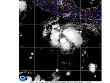
Headline tropical cyclone alerts routinely compress complex atmospheric and coastal dynamics into a single binary label: a storm has strengthened to hurricane status and a landfall or near-coast impact is expected. For anyone evaluating operational exposure along Mexico's coastline, treating "hurricane strengthening near the coast" as a single uniform event obscures the real drivers of risk. A system reaching hurricane wind thresholds offshore creates a fundamentally different hazard profile than one undergoing rapid intensification hours before crossing a shoreline, and a storm tracking parallel to rugged topography behaves differently from one perpendicular to a low-lying plain. This analysis breaks down how tropical cyclone intensification near Mexico translates into physical hazards, operational bottlenecks, and decision trade-offs—without fabricating unverified site-specific telemetry.
Why Headline Status Overstates Certainty and Understates Lead-Time Risk
When a tropical cyclone is reported as strengthening to a hurricane while approaching Mexico's coast, two separate physical claims are being combined: intensity evolution (maximum sustained wind speed and minimum central pressure) and spatial trajectory (track position, translation speed, and wind-field radius). Standard breaking summaries treat both as settled facts or immediate certainties. In practice, each carries a distinct error structure and operational meaning. Recently making headlines recently: Inside Costa Rica's Mega-Prison Turn and the Price of Security.
The Intensity-Track Decoupling Problem
Track forecasts and intensity forecasts do not fail at the same rate or for the same physical reasons. Steering currents in the surrounding troposphere largely govern where a cyclone moves, whereas inner-core thermodynamics, vertical wind shear, oceanic heat content, and entrainment of dry or stable air govern how fast it intensifies or weakens. A system can cross the hurricane threshold on schedule while its track shifts tens or hundreds of kilometers laterally, or it can stall and intensify far faster than linear extrapolation suggests.
Relying on the headline label "hurricane" creates three analytical blind spots: Additional details into this topic are explored by USA Today.
- Threshold illusion: Wind speeds cross categories continuously, yet human and institutional responses often jump in discrete steps. A storm moving from strong tropical storm force to minimal hurricane force changes structural and marine risk incrementally, whereas a storm undergoing rapid intensification compresses preparation windows before peak winds arrive.
- Radius distortion: Maximum sustained wind occurs in a narrow band—typically near the eyewall—while tropical-storm-force and hurricane-force winds extend outward asymmetrically. Coastal exposure depends heavily on how wide that wind field is and which quadrant faces the shoreline.
- Forward-speed sensitivity: A fast-moving hurricane limits localized rainfall accumulation at any single point but shortens evacuation and securing windows. A slow-moving system prolongs wind duration, wave battering, and rain volume over the same municipalities.
Fact Versus Educated Hypothesis in Early Coastal Alerts
Disciplined operational analysis separates observed physical states from conditional projections. A known fact in a standard alert is that a meteorological agency has assessed the system's wind structure to meet or exceed hurricane criteria and identified a coastal corridor within the forecast envelope. An educated hypothesis—even when grounded in sound meteorology—is the exact timing, location, and magnitude of coastal impacts given remaining uncertainty in inner-core structure, steering flow, and land interaction.
Confusing those two categories leads directly to misallocated resources. Treating a conditional coastal track as guaranteed leads to credibility fatigue if the core stays offshore; treating an offshore hurricane as benign because the center is projected to pass parallel to the coast ignores outer-band squalls, swell propagation, and terrain-induced rainfall.
The Coastal Hazard Architecture of a Approaching Hurricane
A tropical cyclone nearing Mexico's coast does not deliver one hazard; it delivers a coupled sequence of atmospheric, oceanographic, and hydrological forces. How those forces interact depends on which side of the country is exposed and what coastal geometry lies in the path.
Wind, Surge, Waves, and Terrain-Driven Rain
Coastal impact severity is governed by four interacting mechanisms rather than sustained wind speed alone:
- Wind-driven stress and structural loading: Peak gusts exceed one-minute or ten-minute sustained winds, particularly in convective rainbands and elevated or exposed structures. Wind direction relative to coastal orientation determines whether onshore push amplifies water levels or offshore flow partially offsets surge while still creating severe crosswinds and flying-debris hazards.
- Storm surge and wave setup: Onshore winds and low barometric pressure push water toward the coast, while breaking waves elevate mean water level along the beach face (wave setup) and send wave run-up higher up slopes and seawalls. Surge magnitude is strongly sensitive to bathymetry—a wide, shallow continental shelf supports higher surge buildup than a steep drop-off—as well as local tidal stage at arrival time.
- Far-field swell and coastal currents: Long-period ocean swells generated by hurricane-force winds radiate outward ahead of the storm center. Even if the cyclone core remains well offshore or turns away, hazardous surf, rip currents, and port disruptions can arrive days ahead of peak winds.
- Orographic and convective rainfall: Mexico features extensive mountain ranges close to both the Pacific and Gulf/Caribbean coasts. When moisture-laden cyclonic inflow impinges on coastal sierras and cordilleras, forced ascent (orographic lift) can trigger intense, prolonged rainfall well inland or along slopes far removed from the point of maximum wind. Flash flooding and landslides frequently cause severe disruption even where wind damage is moderate.
Geographic Asymmetry Along Mexico's Coastlines
Applying a generic coastal template to Mexico fails because coastal physics vary sharply by basin and physiography. On the Pacific side, steep submarine topography near many stretches limits classic wide-shelf surge compared with broad shallow shelves elsewhere, yet proximity to rugged mountain terrain magnifies heavy rain, runoff, and slope instability. On the Gulf and Caribbean sides, flatter coastal plains, lagoons, estuaries, and barrier features create different drainage, inundation, and surge pathways, while peninsular and adjacent landmasses can alter inflow and structure.
Any coastal assessment that omits local bathymetry, elevation, river basin saturation, and wind-quadrant geometry is working with an incomplete physical model.
The Cost Function of Coastal Storm Response
Decision-makers along a threatened coast operate under an asymmetric cost function. Acting too early or too broadly incurs false-alarm and economic-disruption costs—halted shipping, closed facilities, lost workdays, and public skepticism if the worst impacts miss a municipality. Acting too late or too narrowly incurs unmitigated-impact costs—damaged assets, trapped supply chains, prolonged power and water outages, and threat to life.
Why Linear Scaling Breaks Down Under Uncertainty
A common mistake in coastal planning is assuming that a 30% increase in storm threat warrants a 30% increase in response effort. Real-world systems do not scale linearly because of capacity thresholds and lead-time lock-ins.
- Lead-time cliffs: Certain actions—such as moving high-value marine assets, securing cranes and construction sites, staging emergency supplies across flood-prone road networks, and executing vulnerable-population evacuations—require fixed hours or days before arrival of tropical-storm-force conditions. Once wind speeds or heavy rain begin, safe execution drops sharply.
- Coupled infrastructure bottlenecks: Power distribution, telecommunications, port operations, fuel logistics, and drainage networks depend on one another. A localized road washout or substation trip can stall response teams in an adjacent district even when wind speeds there are modest.
- Antecedent condition multipliers: Soil moisture, reservoir levels, and prior maintenance backlogs act as multipliers. A watershed already near saturation converts moderate hurricane rainbands into rapid flooding far faster than dry ground.
The Second Limitation of Static Checklists
Static readiness checklists treat a storm as a fixed schedule rather than a shifting probability distribution. When a hurricane strengthens near the coast, early actions should prioritize reversible, time-sensitive preparations (securing loose materials, verifying backup power and communications, clearing drainage bottlenecks, repositioning mobile assets) while keeping high-cost, irreversible or disruptive actions (full port shutdowns, broad closures, mass evacuations) tied to explicit trigger thresholds and updated forecast cones.
Operational Decision Framework for Near-Coast Hurricanes
To move from headline alarm to disciplined execution, teams and organizations exposed to a strengthening hurricane near Mexico's coast can structure decisions around four sequential stages.
Stage 1: Decompose the Alert Into Five Operational Variables
Before issuing instructions or committing heavy resources, translate the meteorological update into five concrete inputs:
- Current intensity trend: Is the cyclone steadily strengthening, undergoing rapid intensification, or leveling off?
- Closest approach geometry: What is the distance and bearing to key assets or facilities, and how wide is the wind-field envelope relative to that distance?
- Arrival timeline of onset thresholds: When will tropical-storm-force winds, rough seas, or heavy rain arrive—not just when might the center pass?
- Quadrant and wind direction: Will the location experience onshore or offshore flow, and sit on the stronger or weaker side relative to storm motion?
- Local terrain and drainage sensitivity: Is the primary exposure structural wind, coastal inundation/swell, or inland/slope flash flooding and landslides?
Stage 2: Map Actions to Lead Times Rather Than Storm Categories
Category labels summarize wind speed; operational schedules must be governed by hours until onset of hazardous conditions. Work backward from the latest safe time to complete each critical task—accounting for traffic friction, marine transit times, and daylight limits—and set internal decision deadlines ahead of official advisory cutoffs.
Stage 3: Separate Asset Protection From Continuity Operations
Conflating physical asset protection with business or municipal continuity creates confusion during volatile forecasts. Physical protection focuses on preventing structural, equipment, and environmental damage before conditions deteriorate. Continuity focuses on sustaining essential services, communications, and safe personnel welfare under degraded infrastructure. Where full continuity is unsafe or impractical, define a clean controlled-shutdown state and a clear post-storm inspection sequence before restarting operations.
Stage 4: Enforce Post-Passage Hazard Discipline
Risk does not end when the cyclone center passes or weakens below hurricane strength. Post-passage hazards—flooded roads, downed lines, compromised bridges, unstable hillsides, and contaminated water—frequently produce severe secondary impacts after winds subside. Restarting operations requires verification of physical access, utility integrity, and hydrological safety rather than relying solely on sky conditions or wind lull.
Key Analytical Caveats and Blind Spots
Even a rigorous framework has boundaries that practitioners must state explicitly rather than gloss over:
- Data sparsity over open water: Offshore cyclones can still exhibit rapid structural changes when observations are sparse or satellite-derived estimates carry wider margins. Treat single-advisory jumps with caution, and watch multi-advisory trends.
- Hyper-local micro-variability: Broad coastal advisories cannot capture every street-level drainage choke point, local valley funneling, or site-specific building vulnerability. Local ground truth remains essential.
- Compounding multi-hazard sequences: When tropical systems follow one another along the same corridor, damaged infrastructure and saturated ground alter baseline risk for subsequent disturbances in ways standard single-storm assessments may undercount.
The Strategic Play
When a hurricane strengthens near Mexico's coast, treat the headline alert as a timing and exposure trigger, not a finished verdict. Anchor immediate decisions to the arrival window of tropical-storm-force conditions and local water/terrain vulnerabilities rather than waiting for landfall confirmation, execute reversible lead-time-critical preparations early, and lock hard shutdown and evacuation triggers to explicit pre-committed thresholds before local transport and power networks degrade.