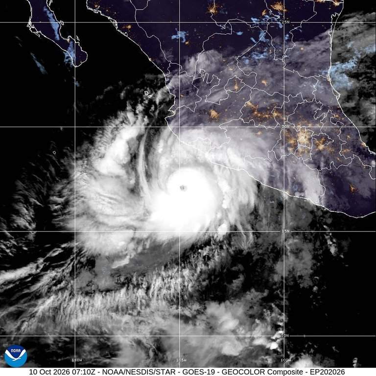
When a storm jumps straight into major hurricane territory, coastal communities don't have hours to waste. That is the exact reality unfolding as Hurricane Simon rapidly intensifies into a dangerous Category 4 system off the western coast of Mexico. With maximum sustained winds hovering near 140 to 150 mph, the U.S. National Hurricane Center has flagged the system as a severe threat capable of catastrophic storm surges and destructive coastal waves.
If you are tracking the storm path or wondering how local infrastructure is holding up, here is what is actually happening on the ground as Simon bears down on the Pacific coastline. You might also find this similar story insightful: Stop Calling Mahmoud Abbas’s 2027 Election Delay a Power Grab Because the Ballot Box Was Already Broken.
The Rapid Surge Toward Landfall
Major hurricanes rarely play by a slow rulebook, and Simon is a textbook example of explosive marine intensification. Fueled by warm Pacific waters and favorable atmospheric conditions—including reduced wind shear often tied to broader seasonal patterns like El Niño—the storm quickly packed a punch.
Forecasters track Simon moving steadily toward Mexico's west-central Pacific coast, putting tourist hotspots and residential areas directly in the crosshairs. Cities like Puerto Vallarta and surrounding coastal stretches in Jalisco state have shifted into emergency preparation mode. Authorities pushed for mandatory shelter accommodations and warned residents to lock down loose outdoor items before conditions deteriorated rapidly. As extensively documented in latest reports by Reuters, the implications are notable.
On the Ground in Puerto Vallarta and Beyond
Local reactions to major incoming storms often mix nervous energy with a stubborn sense of calm. In Puerto Vallarta, storefronts saw shop owners hurriedly piling sandbags and slapping plywood over windows while tourists tried to salvage anniversary trips or weekend getaways before local authorities ordered everyone indoors.
Farther south, areas like Acapulco already felt the brutal tail end of Simon's outer bands, experiencing heavy downpours and localized landslides that blocked roadways. The geography of the region—featuring sweeping bays and steep, mountainous terrain—creates a double-edged sword. While natural bays can blunt initial wave impacts, the rugged inland geography guarantees massive rainfall totals, elevating the risk of flash floods and mudslides as the core pushes onshore.
What Comes Next for the Coast
As Simon interacts with Mexico's mountainous interior, meteorologists expect the storm to start a gradual weakening trend
Why Hurricane Simon Taking Aim at Mexico is Worrisome
news
Ocean waters warm up and storms turn terrifying overnight. That is basically what happened when Hurricane Simon rapidly escalated into a dangerous Category 4 storm barreling toward the Pacific coast of Mexico. If you live anywhere near the path or have family in the region, you aren't thinking about meteorological jargon. You are watching the radar maps and wondering how hard the impact will hit.
Storms like Simon don't just happen in a vacuum. They feed on specific ocean temperatures and atmospheric conditions that turn a basic tropical depression into an absolute monster. Understanding how Simon reached Category 4 status requires looking past the basic weather reports and seeing the physical mechanics at play off the Mexican coastline.
The Warning Signs Nobody Talks About
Most people look at a hurricane track and fixate only on the center line. That is a massive mistake. Hurricanes are wide-reaching weather engines. When Simon reached Category 4 strength, sustained winds jumped significantly, pushing heavy moisture and rough surf far ahead of the actual eye wall.
Warm sea surface temperatures off the western coast of Mexico acted like rocket fuel for this system. Tropical moisture pooled together, atmospheric pressure dropped rapidly, and the storm organized its core structure with terrifying speed. Meteorologists tracking the system saw rapid intensification occur in a matter of hours. That sudden spike catches coastal communities off guard because evacuation timelines shrink to almost nothing.
What Coastal Communities Face Right Now
Living through a Category 4 hurricane changes everything in your immediate environment. Power grids fail. Roads wash out from flash flooding. Storm surge pushes massive walls of seawater inland, wiping out beachfront structures and flooding low-lying neighborhoods.
Emergency management teams in Baja California Sur and surrounding coastal zones scrambled to issue warnings as Simon strengthened. Shelters opened. Boats pulled into safe harbors. Yet, emergency prep always hits the same wall. People underestimate the water. Wind gets all the attention, but rising water causes the majority of fatalities during severe tropical events.
Why Rapid Intensification is Becoming the New Normal
Storms jumping multiple categories in a single day used to be rare anomalies. Now they happen with alarming regularity. Warm ocean heat content plays the starring role here. When deep layers of warm water sit off a coastline, passing storms pull that thermal energy straight upward.
Simon followed this exact playbook. It tracked over favorable waters with minimal wind shear to disrupt its circulation. Once the inner core formed a tight pinhole eye, the thermodynamic engine locked in.
Practical Steps If You Are in the Impact Zone
If you find yourself facing a storm of this magnitude, standard emergency checklists apply, but execution matters more than ever.
- Secure loose outdoor items immediately before wind turns them into projectiles.
- Fill clean containers with drinking water because municipal water systems often fail or get contaminated.
- Keep your fuel tank full and mobile devices charged while the power grid is still operational.
- Know your local evacuation route and leave early if local authorities give the word. Staying behind during a Category 4 event cuts off rescue options once winds exceed safe thresholds for emergency vehicles.
Storms pass eventually, but the recovery takes months. Pay attention to local civil protection updates rather than scrolling through unverified social media rumors. Preparation remains the single best defense against an unpredictable ocean.