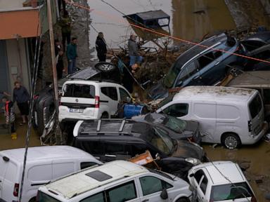
Standard disaster reporting treats Istanbul's October 2026 flood disaster—which left at least four people dead and surpassed the city's rainfall benchmark since 1942—as an isolated meteorological shock. That framing misses the structural mechanics that turn intense rainfall into mass disruption across a city of roughly 16 million residents. When downpours deliver more rain in 48 hours than the combined historical average for September and October, the critical failure point is rarely the sky alone; it is the interaction between steep topography, impervious ground cover, constrained drainage conduits, and human exposure along natural water paths.
Deconstructing conventional coverage exposes a recurring analytical gap. Headlines tally fatalities, quote emergency officials, and list immediate disruptions such as flooded streets, swept-away vehicles, and school closures. What goes unexamined is how hydrological load propagates through a dense urban system. A rigorous assessment requires separating confirmed operational facts from educated hypotheses about urban design, and evaluating municipal response through clear structural models rather than narrative drama.
Deconstructing Competitor Logic and the Analytical Gap
Typical news dispatches rely on a simple linear sequence: extreme rain falls, drainage is overwhelmed, neighborhoods flood, and emergency crews respond. That sequence describes symptoms rather than system architecture. Listing four fatalities—including a teenager electrocuted in Balat and a 66-year-old man found beneath a bridge in Sarıyer—alongside 9,850 damage reports and roughly 46,000 response personnel gives scale, yet stops short of explaining why specific zones fail while adjacent blocks remain passable.
The first analytical flaw in surface reporting is treating rainfall volume as a uniform blanket across the metropolitan area. In hilly terrain bordering the Bosphorus and Marmara basins, localized intensity and slope gradients concentrate runoff into narrow channels and low-lying basins. Vehicles piling up at the bottom of hills is not an incidental visual detail; it is a direct readout of kinetic energy and surface flow velocity along steep roadways.
The second analytical flaw is conflating short-term weather variability with long-term structural exposure. Officials have linked the event both to climate shifts and to construction near waterways. Reporting those remarks side by side without separating atmospheric forcing from land-use vulnerability blurs two distinct policy levers. One governs emission trajectories and regional climate patterns; the other governs zoning enforcement, setback compliance, and channel capacity.
The Four Structural Pillars of Urban Flood Severity
To evaluate a flood event like Istanbul's October 2026 deluge with operational precision, analysts can organize the system around four interacting pillars: Hydrological Load, Runoff Conversion, Conduit and Basin Capacity, and Exposure and Secondary Hazards.
- Hydrological Load: Defined by total precipitation depth, peak rainfall intensity per hour, and forecast error. When rainfall reaches extreme totals—reported locally up to 272 mm in hard-hit areas against a meteorological forecast of 75 mm—system planners face both volume shock and lead-time compression.
- Runoff Conversion: The share of rainfall that becomes fast surface flow rather than infiltrating soil or detaining in vegetation. Expansion of paved surfaces, roofs, and compacted ground raises the runoff coefficient, accelerating peak discharge into streets and gullies.
- Conduit and Basin Capacity: The physical throughput of storm drains, culverts, natural streambeds, and retention spaces. Debris mobilization during heavy flows—mud, branches, and urban refuse—can choke grates and bridges, cutting effective capacity mid-storm.
- Exposure and Secondary Hazards: The spatial overlap of floodwater with people, basements, transit corridors, and energized or unstable infrastructure. Electro-mechanical failures, submerged electrical lines, landslides on saturated slopes, and bridge or building instability compound direct water damage.
Causality runs sequentially through these four pillars, with feedback loops that worsen outcomes. High hydrological load hits high-runoff surfaces, generating rapid overland flow that tests conduit limits. Once surface channels overflow, water enters basements, subway stations, and utility trenches, creating secondary hazards such as power outages, water supply interruptions, and electrocution risks that slow rescue and repair operations.
Separating Confirmed Facts from Educated Hypotheses
Disciplined crisis analysis requires strict epistemic hygiene. Separating verified reporting from analytical hypotheses prevents policy overreach and keeps operational decisions grounded.
Known Facts:
- Torrential rain in mid-October 2026 triggered severe flooding in Istanbul and across northwestern Türkiye, with interior ministry officials characterizing the event as the worst flood disaster since 1942.
- At least four deaths were reported in Istanbul—including fatalities linked to electrocution in Balat and a body found under a bridge in Sarıyer—alongside thousands of displaced residents, widespread damage reports, and tens of thousands of personnel deployed for response and cleanup.
- Floodwaters inundated streets, homes, businesses, and transit infrastructure, triggered landslides, and caused power and water disruptions in affected districts.
Educated Hypotheses:
- Encroachment on natural floodplains and narrow stream corridors likely amplified peak water levels and structural damage in localized pockets, consistent with public statements raising questions about building near waterways.
- Forecast under-prediction relative to localized convective extremes probably reduced pre-event evacuation and drainage-clearing lead times in high-risk micro-basins.
- Debris transport and surface runoff velocity on sloped arteries likely played a major role in localized road failures, vehicle pileups, and culvert bottlenecks.
These hypotheses remain provisional until post-event hydrological modeling, gauge records, and parcel-level damage audits are reconciled. Treating an educated hypothesis as proven fact weakens credibility; ignoring a plausible hypothesis leaves known vulnerabilities unaddressed.
Why Standard Flood Metrics Mislead Decision-Makers
City leaders and commentators frequently judge flood severity by headline death tolls, 24-hour or 48-hour rainfall totals, or total personnel mobilized. Each metric captures part of the story while masking critical operational trade-offs.
A low or moderate fatality count in a megacity of 16 million does not prove systemic resilience. Evacuation warnings, shelter availability, and luck in timing or location can keep mortality lower than in a smaller or less-connected region, even when economic and infrastructure damage is severe. Conversely, measuring success by the raw number of cleanup personnel deployed tracks input effort rather than bottleneck clearance, such as restoring hospital power, reopening arterial transit corridors, or stabilizing compromised slopes.
Rainfall averages over large metropolitan footprints are equally deceptive. Convective storms often peak in narrow bands over specific watersheds or hillsides. Evaluating a citywide average against historical norms can obscure extreme localized spikes that overwhelm specific drainage sub-networks while leaving neighboring districts relatively dry.
Operational Playbook for Extreme Rainfall Response
From an operational and risk-management standpoint, handling extreme multi-day rain events requires disciplined execution across three sequential phases rather than reactive improvisation.
- Pre-Event Hardening and Staging: Before heavy rain arrives, municipal engineering and emergency teams must prioritize clearing inlet grates, culverts, and sediment traps in known flood-prone basins and steep hillside corridors. Pre-positioning pumps, earthmoving gear, and utility shutoff crews near low-lying transit hubs and electrical substations cuts response lag once roads flood.
- Event-Time Triage and Hazard Isolation: During active downpours, dispatch priorities should center on life-safety hazards: isolating downed or submerged electrical circuits, halting transit operations where water approaches station or tunnel thresholds, and moving residents out of basements and stream-adjacent structures. Real-time reporting from field units should be sorted by cascading risk—such as landslides blocking access roads or utility faults threatening nearby blocks—rather than handled strictly in arrival order.
- Post-Event Restoration and Forensic Audit: Once waters recede, recovery teams should sequence restoration by system interdependence—stabilizing slopes and bridges, restoring water and power safely, and clearing mud and debris from primary arteries before secondary streets. Immediately afterward, engineers should map every flooded property and failed drain against rainfall intensity and elevation data to update flood maps and enforcement priorities.
Every intervention carries practical limits and trade-offs. Retrofitting dense, historic, or rapidly built urban neighborhoods is expensive, legally complex, and constrained by underground utilities and existing property lines. Weather models face inherent physics limits when resolving intense, localized rainfall cells ahead of time, meaning no early-warning system can eliminate forecast uncertainty completely.
Strategic Action for Municipal and Infrastructure Leaders
Establish a mandatory Watershed-to-Parcel Flood Stress Ledger across high-risk municipal basins before the next severe wet season, pairing high-resolution elevation and drainage capacity data with utility and building vulnerability records. Rather than relying solely on broad climate pledges or ad-hoc cleanup drives after storms hit, use that ledger to enforce strict no-build or setback rules in active floodways, automate pre-storm utility isolation protocols in flood-prone zones, and direct capital upgrades to the exact bottlenecks where surface runoff and infrastructure exposure intersect.