Walk into any travel bookstore, search the deepest corners of the internet, or consult a standard guidebook, and you will find them. The "Top 10 Tallest Waterfalls" lists. They are presented with the confidence of mathematical absolute, featuring glossy photos of Angel Falls in Venezuela and Olo’Upena in Hawaii. These lists serve as a kind of tourism bait, a promise that if you travel to these coordinates, you will witness the record-holding peak of natural height.
The reality is far more inconvenient for the tourism industry. The entire premise of ranking the world's tallest waterfalls is fundamentally broken. We are measuring shifting water against static maps, applying human definitions to fluid geological features that change their dimensions with every rainy season.
The "Tallest" title is not a settled scientific fact. It is a source of bitter, ongoing contention among cartographers, hydrologists, and adventure-seeking surveyors. If you are looking for an objective, undisputed king of vertical drops, you will not find one. You will find only a collection of estimates, conflicting methodologies, and a deep, systemic failure to account for how waterfalls actually exist in the physical world.
The Geography of Disputed Height
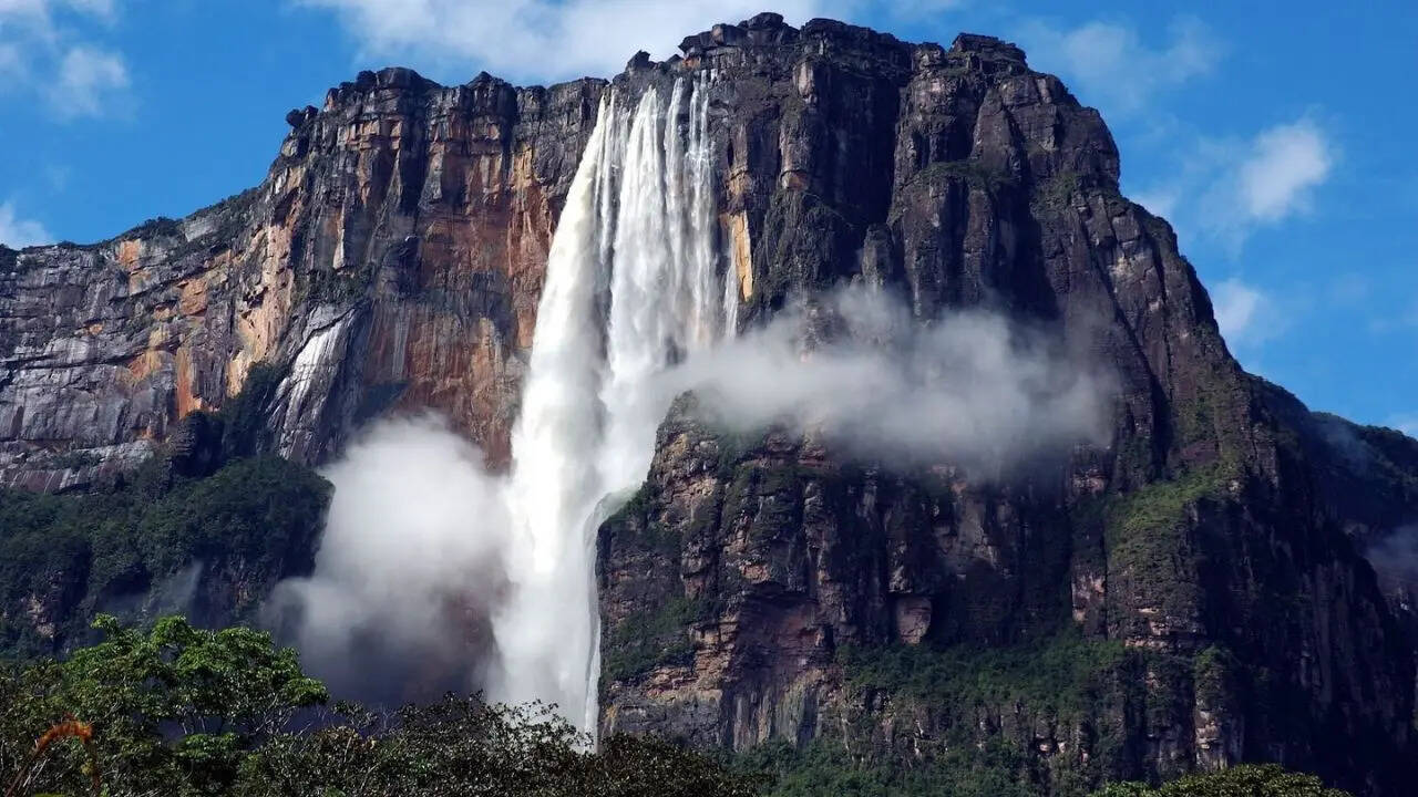
The central conflict in this world of giants is the duel between Angel Falls in Venezuela and Tugela Falls in South Africa. For decades, Angel Falls held the crown, solidified in the public imagination by a 1949 survey. It was cited as 979 meters (3,212 feet) tall. That figure became gospel. It appeared in textbooks, encyclopedias, and travel brochures globally.
Then, the technology of measurement evolved. When surveyors returned to these sites with modern laser rangefinders and refined topographic data, the 1949 numbers began to look like convenient approximations rather than precise measurements. Some studies now suggest that the Angel Falls figure includes a significant amount of "cascading" distance—water running over rocks at a shallow angle—rather than a true, uninterrupted free-fall.
Suddenly, Tugela Falls entered the conversation. Situated in the Drakensberg mountains of South Africa, Tugela was long considered a runner-up. However, subsequent expeditions, including a notable 2016 survey by a Czech team, suggested its total height was underestimated, potentially pushing it beyond the revised measurements of Angel Falls.
This triggers the immediate, unresolved question: how do we define a single waterfall?
If a waterfall drops 400 meters, runs across a plateau for half a kilometer, and then drops another 300 meters, is that one waterfall or two? There is no global standard. Some databases count the cumulative drop of these tiers. Others insist on a "single uninterrupted drop" as the only metric worth recording.
The Flaw in the Measuring Tape
The problem is one of access and physics. A laser rangefinder requires a clear line of sight from a stable platform. Many of these falls are tucked into remote ravines, shrouded in mist, or located on sheer cliff faces that are nearly impossible to stand safely in front of.
Topographic maps, another primary source for these rankings, rely on contour lines. These lines indicate elevation changes, but they cannot see through dense vegetation or around jagged rock formations. If a map indicates a drop based on elevation markers spaced 50 meters apart, that map is effectively guessing what happens between those markers.
There is also the matter of volume and seasonality. Many of the contenders for the "tallest" title are ephemeral. They are fed by snowmelt or seasonal rainfall. In the height of the dry season, they may shrink to a mere trickle or disappear entirely, rendering the concept of a "waterfall" questionable. Yet, they remain on the lists, clinging to their rankings based on their maximum potential flow during the wettest week of the year.
This creates a perverse incentive for tourism boards and local governments to inflate measurements. A "record-holding" status guarantees tourist dollars. An unranked, "merely tall" waterfall receives significantly less funding and foot traffic.
Beyond the Vanity Metric
The obsession with being the tallest obscures the far more interesting geological reality of these sites. The erosion that creates these falls is a slow-motion destruction of the mountain itself. Every year, millions of tons of water pound against the lip of the precipice, grinding away the bedrock.
Consider the Yumbilla Falls in Peru or Vinnufossen in Norway. These are not just statistics to be checked off; they are living, changing systems. Their heights are not fixed. They are dynamic indicators of the climate and rock stability of their regions. When we obsess over whether one is three meters taller than the other, we ignore the fact that the waterfall you visit today is physically different from the one that existed a century ago.
The rankings are a snapshot of a moment that has already passed. The earth is constantly reshaped by the very water that gives these features their names. To treat these places as static entries in a database is to misunderstand the nature of the terrain entirely.
When you stand at the base of a massive drop—whether it is officially the first, second, or tenth tallest—the number assigned to it by a surveyor thousands of miles away becomes irrelevant. The spray on your face, the roar of the water, and the sheer scale of the geological forces at work do not require a title to validate their power. The next time you see a "definitive" list, remember that the only thing truly being measured is the human desire to categorize the uncontainable.