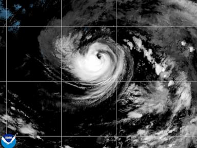
Oceanic and atmospheric coupling dictates that tropical cyclogenesis is fundamentally an engine of heat conversion. When Karina transitioned from a disorganized low-pressure anomaly into a Category 1 hurricane in the Eastern Pacific, it did so by exploiting precise thermal gradients and low wind-shear boundaries. Media reports framing this event as a sudden atmospheric anomaly miss the underlying structural mechanics. Understanding why Karina scaled to hurricane intensity requires examining the thermodynamic efficiency of the upper ocean and the specific kinetic feedback loops governing convective organization.
The Thermodynamic Thresholds of Rapid Intensification
A tropical cyclone operates as a Carnot heat engine, extracting thermal energy from a warm ocean surface and dissipating it into the cold upper troposphere. The efficiency of this engine is bound by the temperature differential between the sea surface temperature and the outflow temperature at the cloud tops. For Karina, the operational environment presented a high-enthalpy fuel source combined with minimal upper-level wind shear.
When vertical wind shear remains low, the convective chimney—the column of rising warm, moist air—remains vertically aligned over the surface low-pressure center. This vertical stacking prevents the latent heat released by condensation from being blown away from the core.
The structural transition from a 45 mph tropical storm to an 80 mph hurricane over open water maps directly to the following operational variables:
- Ocean Heat Content: Sea surface temperatures exceeding the critical 26.5°C threshold provide the necessary sensible and latent heat fluxes.
- Mid-Tropospheric Humidity: A sufficiently saturated mid-level environment prevents entrainment—the mixing of dry air into the core—which otherwise would evaporate cloud water, cool the updraft, and choke the thermal engine.
- Coriolis Parameter and Vorticity: Initial low-level spin must be concentrated within a tight radius to spin up a closed eyewall, transitioning the system from a broad vortex to an intense, concentrated pressure gradient.
The Mechanics of Open-Ocean Propagation and Remote Impacts
Because Karina tracked approximately 820 miles southwest of the Baja California Peninsula on a northwest trajectory into the open Pacific, direct landfall risks remained zero. However, evaluating a storm's operational footprint purely by its center-point vector ignores spatial physics. Cyclones displace massive volumes of water, generating long-period swells that propagate far outside the gale-radius.
The kinetic energy transferred from the wind stress to the ocean surface generates wave trains that travel outward at high phase speeds. Even though the core winds stayed well offshore, these kinetic energy waves manifested as hazardous surf and rip currents along portions of southwest Mexico and the Baja California coastline. This demonstrates a critical analytical takeaway: remote storms exert localized coastal hazards via wave dispersion long before or entirely independent of wind-field impact.
Predictive Limitations in Modern Cyclone Forecasting
Despite advancements in numerical weather prediction models—such as the Global Forecast System and the Integrated Forecasting System—forecasting the exact peak intensity and timing of intensification cycles remains probabilistic rather than deterministic. Satellite-based remote sensing, including microwave imagery and scatterometry, allows meteorologists to measure surface wind vectors and inner-core structure, yet internal eyewall dynamics introduce high sensitivity to initial conditions.
The primary limitation in forecasting strength trajectories lies in measuring microscale boundary-layer fluxes. Small-scale variations in sea surface temperature anomalies, ocean eddies, and sub-surface mixing alter the energy flux into the storm's base. When a hurricane draws heat from the ocean, it simultaneously upwells cooler water from below, creating a negative feedback loop that can cap intensity. Accurately modeling whether a storm overcomes this upwelling limit dictates whether it stalls at Category 1 or transitions into a major Category 3-plus system.
Monitor structural core symmetry via microwave satellite passes to assess whether concentric eyewall replacement cycles are initiating, as these cycles dictate the short-term ceiling of intensity changes before any secondary intensification phase.